
Upper Level Winds
Factors Affecting Wind Velocity
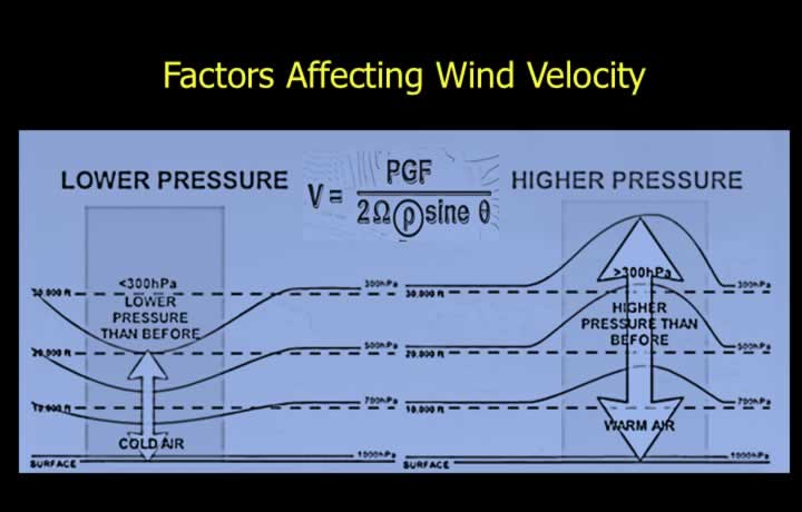
- Wind velocity in the upper atmosphere is inversely proportional to air density.
- Wind speeds increase with height up to the tropopause due to decreasing density.
- Wind velocity is directly proportional to the Pressure Gradient Force (PGF).
- At a given altitude, lower pressure is observed in cold air masses compared to warm air masses.
- Stronger temperature differences create a stronger Pressure Gradient Force.
- High wind speeds are expected in regions with significant temperature contrasts due to stronger PGF.
Contour Charts
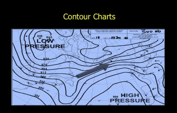
- Contour Charts are maps showing lines of equal pressure or geo-potential height (Isohypses).
- Closely spaced isohypses indicate strong temperature and pressure gradients, resulting in higher wind speeds.
- A 300 mb chart shows contours of equal height where pressure equals 300 mb.
- In cold air, the 300 mb level occurs at lower heights, indicating lower geo-potential height.
- In warm air, the 300 mb level occurs at higher heights, indicating higher geo-potential height.
Extended Buys Ballot’s Law
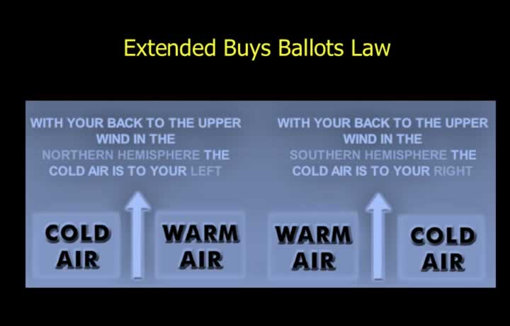
- Extended Buys Ballot’s Law describes wind direction in the upper atmosphere.
- In the Northern Hemisphere, with your back to the upper-level wind, cold air is to your left.
- In the Southern Hemisphere, with your back to the upper-level wind, cold air is to your right.
Upper Winds in Temperate Latitudes
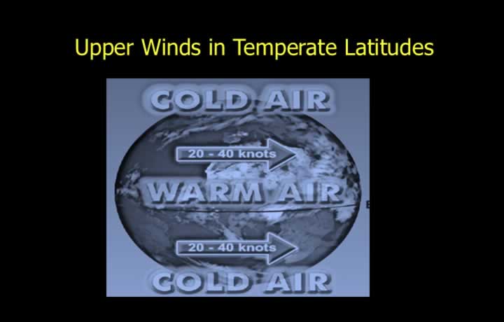
- Polar regions are colder than equatorial regions, creating strong temperature gradients.
- As a result, westerly winds dominate in both hemispheres.
- In the Northern Hemisphere, cold air lies to the left of the flow.
- In the Southern Hemisphere, cold air lies to the right of the flow.
- Typical wind speeds:
- ~20 knots at 20° latitude
- ~40 knots at 60° latitude
Upper Winds in Equatorial Regions
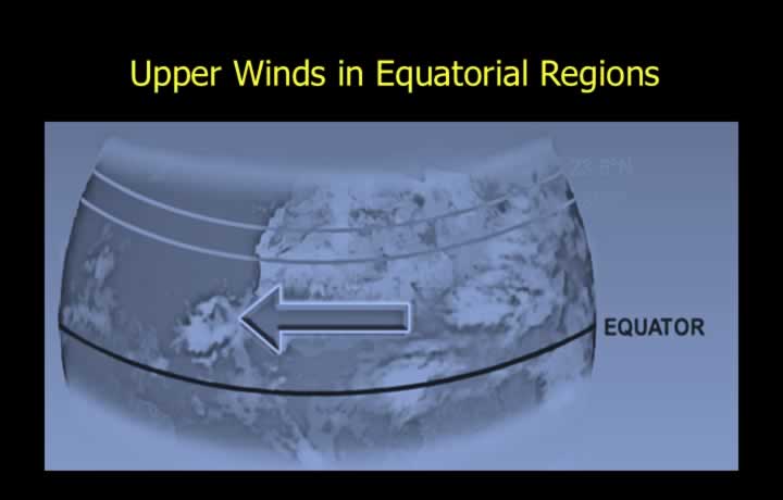
- The thermal equator shifts northward during Northern Hemisphere summer.
- At times, 23.5°N becomes warmer than the equator due to land heating.
- Easterly winds are observed in both hemispheres in equatorial regions during summer conditions.
- These occur due to the reversed temperature gradient near the equator.
Jet Streams
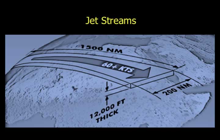
- Jet Streams are narrow bands of strong winds in the upper troposphere.
- Wind speeds exceed 60 knots.
- They are caused by strong horizontal temperature gradients and result in wind shear.
- Typical dimensions:
- Length: up to 1500 km
- Width: ~200 km
- Vertical depth: ~1200 ft
- The axis is the central line of maximum wind speed.
- The core is the region surrounding the axis with the strongest winds (110–180 knots or more).
Upper Air Spot Wind Charts
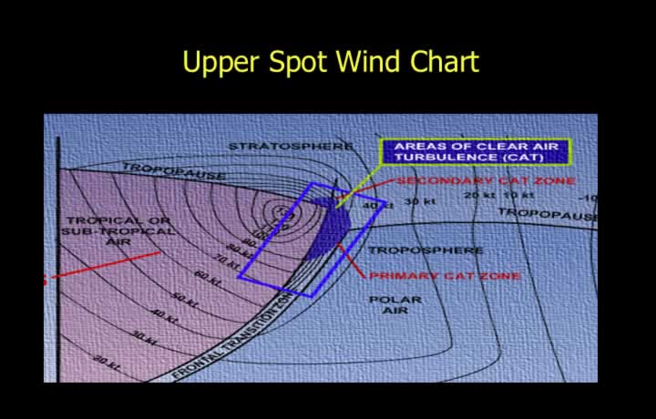
- Jet streams are associated with frontal zones due to strong temperature contrasts.
- They are identified on upper air charts where wind speeds exceed 60 knots.
- Jet streams typically occur just below the tropopause.
- They are prominent near the fringes of weather systems.
- They are also intensified on the leeward side of mountain ranges.
- Mountain waves and jet streams together can cause severe Clear Air Turbulence (CAT), often indicated by lenticular clouds.
Subtropical Jet Stream (STJ)
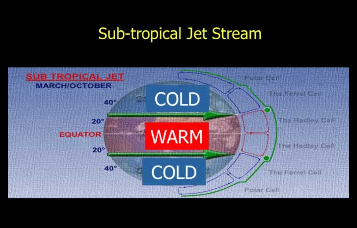
- The Subtropical Jet Stream is a strong westerly jet found near 30° latitude.
- It occurs at about 9–12 km altitude (~200 hPa level).
- It forms at the boundary between the Hadley and Ferrel cells.
- Winter:
- Strong (100–200 knots)
- Located near ~27°N
- Lower altitude due to lower tropopause
- Summer:
- Weaker
- Shifted toward ~35°N
- Can intensify up to 400 knots south of the Tibetan Plateau due to strong thermal contrast between land and ocean.
Indian Subtropical Jet Stream
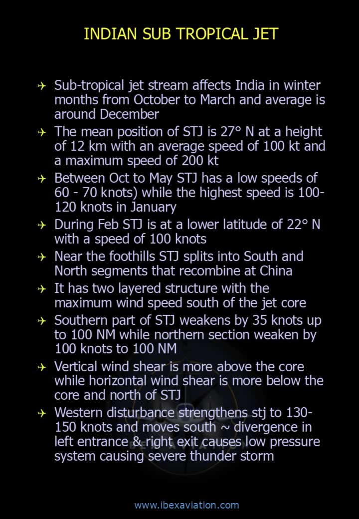
- Influences India mainly from October to March, strongest around December–January.
- Mean position: ~27°N at ~12 km altitude.
- Average wind speed: ~100 knots; peaks up to 200 knots.
- Between October–May: typically 60–70 knots.
- January peak: 100–120 knots.
- In February, it shifts south to ~22°N with ~100 knots speed.
- It may split near foothills and rejoin over China.
- Strong vertical and horizontal wind shear occurs around the jet core.
- Western disturbances can intensify it to 130–150 knots.
Polar Front Jet (PFJ)
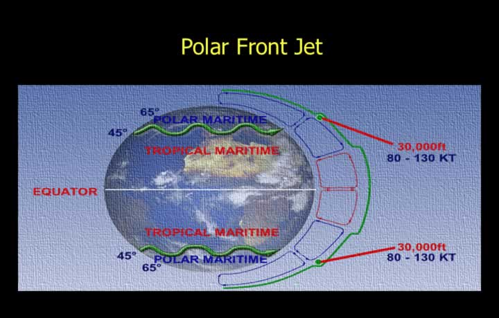
- The Polar Front Jet forms at the boundary between polar and Ferrel cells.
- It separates cold polar air from warmer mid-latitude air.
- It is a strong westerly jet in mid-latitudes (~9 km altitude).
- Winter: 80–100 knots near ~30°N.
- Summer: weaker and shifts poleward toward ~70°N.
Arctic Jet
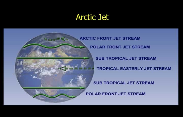
- Arctic jets occur over the Arctic front during winter.
- They form at the boundary between very cold Arctic air and slightly warmer polar air.
- Altitude is lower (~7–8 km) due to lower tropopause height.
Tropical Easterly Jet (TEJ)
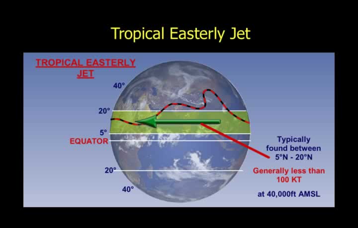
- The Tropical Easterly Jet is a strong easterly wind in the upper troposphere during summer.
- It forms due to northward shift of the thermal equator and heating of the Tibetan Plateau.
- Occurs mainly south of ~25° latitude at ~100 hPa (~16 km / 50,000 ft).
- Found over Asia and Africa, not typically over oceans.
- Wind speeds range from 80–100 knots, sometimes reaching 150 knots.
- Most prominent over peninsular India (June–August).
Low-Level and Stratospheric Jets
- Low-Level Jets: Occur at 1–3 km altitude, especially in subtropical regions.
- Over India, they strengthen the Southwest Monsoon, particularly along the Somali coast.
- Stratospheric Jets: Occur around 20 km in polar regions.
- They are westerly in winter and easterly in summer.
Effects of Jet Streams
- In the Northern Hemisphere, cold air lies to the left when facing the jet stream.
- In the Southern Hemisphere, cold air lies to the right.
- Cloud patterns:
- Roll-type clouds form on the warm side.
- Cirrus clouds form on the cold side near the tropopause.
- A thin haze layer is often present on the warm side.
- Clear Air Turbulence (CAT) occurs near jet boundaries due to strong wind shear.
- CAT is strongest below the jet axis on the cold side.
- Mountain wave interactions can intensify turbulence significantly.