
Surface Winds
Surface winds are winds that blow close to the Earth’s surface. They are caused by differences in air pressure and are affected by the Earth’s rotation and landforms. Surface winds help distribute heat and moisture around the planet.Surface winds vary due to differences in air pressure, temperature, and the Earth’s rotation. Their speed and direction change with the seasons, local weather, and landforms such as mountains and valleys. Coastal areas also experience daily changes in winds, such as sea breezes and land breezes.
Wind Direction
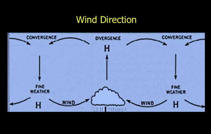
- Winds refers to the horizontal movement of air and is a vector having both direction and speed.
- Wind direction is reported as the direction from which the wind is blowing, referenced to True North.
- Veering refers to a clockwise change in wind direction.
- Winds generally veer in high-pressure systems.
- Backing refers to an anticlockwise change in wind direction.
- Winds generally back in low-pressure systems.
Wind Speed
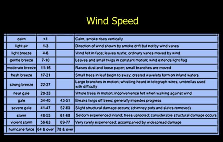
- Wind speed is normally expressed in knots (kt), usually in intervals of 5 knots.
- Wind speed may also be reported in km/h.
- Approximate conversion:
- 1 knot ≈ 2 km/h
- The Beaufort Scale provides an approximate estimate of wind strength based on natural observations.
Surface Wind Measurement
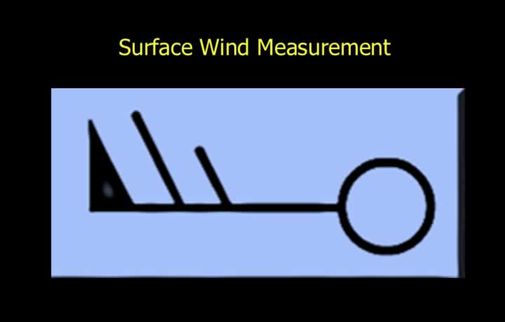
- An Anemometer measures wind speed.
- A Wind Vane measures wind direction.
- Upper-level winds are measured using a Pilot Balloon (PIBAL).
- Surface winds are measured at a height of 10 m above the ground in an open area free from obstructions.
- Routine surface wind observations are averaged over 10 minutes.
- Take-off and landing winds provided by ATC are averaged over 2 minutes.
Gust, Squall and Gale Winds
- Gust is a sudden increase in wind speed.
- Lull is a sudden decrease in wind speed lasting for less than one minute.
- Squall is a sudden increase in wind speed of at least 16 knots, raising the wind speed to more than 22 knots, and lasting for at least 1 minute.
- Gale is a persistent mean wind speed of at least 34 knots.
Localised Wind Patterns in Valleys and Coastal Areas
Sea Breeze
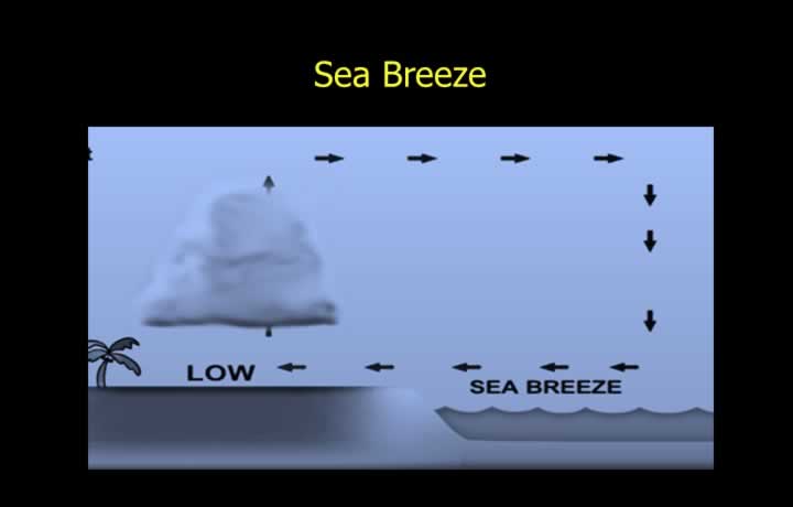
- Sea Breeze is a cool wind that blows from the sea toward the land during the afternoon in coastal areas.
- Land heats faster than the sea because land has a lower specific heat.
- Warm, less dense air rises over the land, creating a surface low-pressure area.
- Cooler air from the sea moves inland to replace the rising air.
- The circulation usually extends up to about 1000 ft.
- Sea breeze often produces cloud development along the coastline.
- It may occur even when no major pressure system is present.
Land Breeze
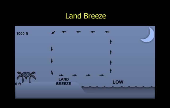
- Land Breeze is the wind that blows from land toward the sea during the night.
- Land cools faster than the sea after sunset.
- The relatively warmer air over the sea rises, creating a pressure difference.
- Cool air flows from the land toward the sea.
- The circulation generally extends up to about 1000 ft.
- The strongest land breeze usually occurs around sunrise, when the land temperature is at its lowest.
Monsoons
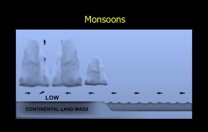
- Monsoon refers to the seasonal reversal of winds.
- During summer, land heats much faster than the sea.
- Rising warm air over land creates a seasonal low-pressure area.
- This draws cool, moist air from the sea toward the land.
- The moist air produces widespread cloud formation and monsoon rainfall.
Anabatic and Katabatic Winds
Anabatic Winds
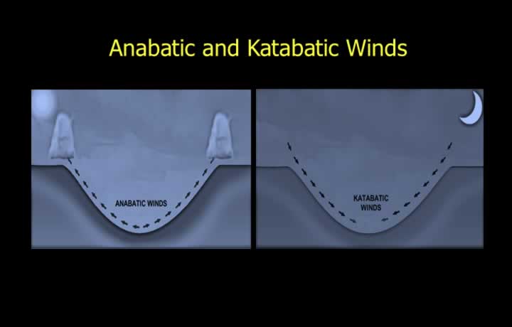
- Anabatic Winds are warm winds that move upslope during the daytime.
- Valley floors heat rapidly, warming the adjacent air.
- The warm, less dense air rises along the mountain slopes.
- This often leads to cloud formation over hilltops.
Katabatic Winds
- Katabatic Winds are cold winds that flow downslope during the night.
- Mountain slopes cool rapidly after sunset.
- The cold, dense air descends into the valleys.
- Katabatic winds frequently produce valley fog during calm nights.
Foehn (Lee) Winds
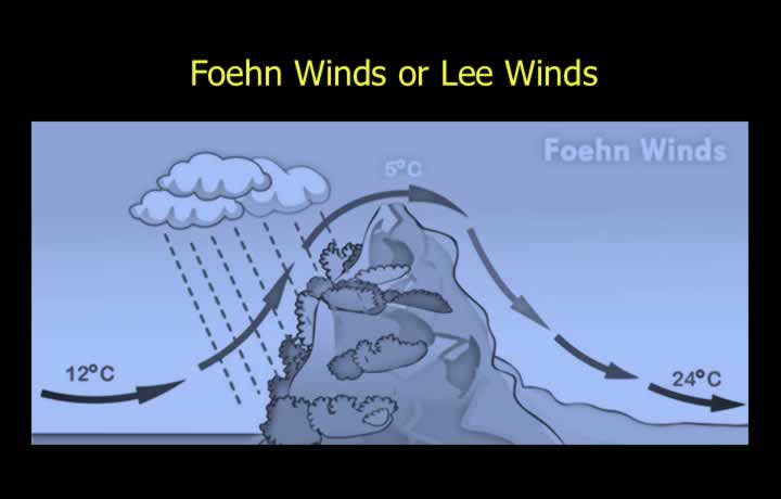
- Foehn Winds (or Lee Winds) are warm, dry winds descending the leeward side of mountains, particularly where mountain ranges lie close to coastlines.
- Moist air from the sea is forced to rise over the windward slope.
- As the air rises, it cools, forming clouds and precipitation on the windward side.
- After losing much of its moisture, the air descends the leeward slope.
- The descending air warms adiabatically, producing warm, dry Foehn (Lee) winds.