Measurement of Aircraft’s Altitude using Pressure Altimeter
A pressure altimeter measures an aircraft’s altitude by sensing the surrounding atmospheric pressure.
As the aircraft climbs, air pressure decreases, and the altimeter converts this pressure change into an altitude reading. It is calibrated using standard atmospheric pressure to provide accurate altitude information.
Pressure Altimeter
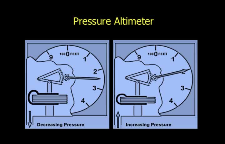
- A Pressure Altimeter is an aneroid barometer that determines the altitude of an aircraft.
- Atmospheric pressure decreases with increasing altitude.
- The altimeter measures the static pressure outside the aircraft and converts it into altitude.
Mean Sea Level (MSL)
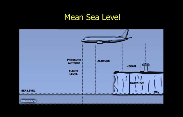
- Mean Sea Level (MSL) is the average sea level calculated over a long period by averaging tidal variations.
- MSL is the standard datum used for measuring altitude and elevation.
- Altitude is the vertical distance of a movable object above Mean Sea Level.
- Elevation is the vertical distance of a fixed point on the Earth’s surface above Mean Sea Level.
- Both altitude and elevation are expressed as Above Mean Sea Level (AMSL).
Aerodrome Reference Point (ARP)
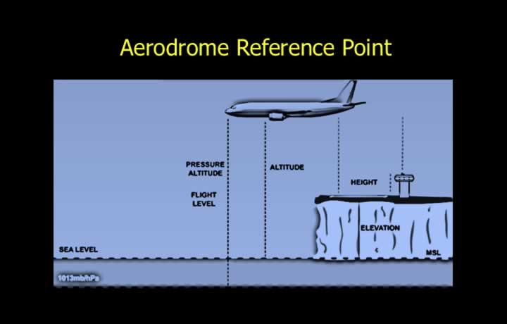
- The Aerodrome Reference Point (ARP) is the reference point for an airfield.
- ARP is the datum used for measuring height above the airfield.
- Height is the vertical distance above a specified datum.
- Height above an airfield is expressed as Above Ground Level (AGL).
Pressure Altitude
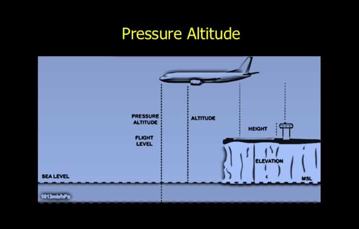
- Standard Pressure Setting (SPS) is the pressure at Mean Sea Level under ISA conditions.
- Standard Pressure Setting = 1013.25 hPa.
- Pressure Altitude is the altitude indicated when the altimeter subscale is set to the Standard Pressure Setting.
Datum Setting for Pressure Altimeter
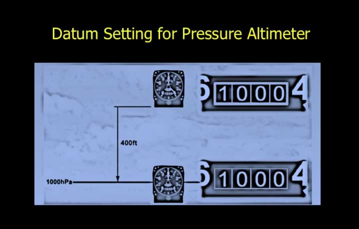
The altitude indicated by a pressure altimeter is derived from the selected datum pressure using the International Standard Atmosphere (ISA).
For example, when the altimeter subscale is set to 1000 hPa:
- The altimeter compares the prevailing atmospheric pressure with the selected datum pressure.
- The pressure difference is converted into height according to ISA conditions.
- The corresponding altitude is displayed on the circular dial.
- Therefore, indicated altitude equals true altitude only under ISA conditions at Mean Sea Level.
Q Codes used in Altitude Measurement
QFE
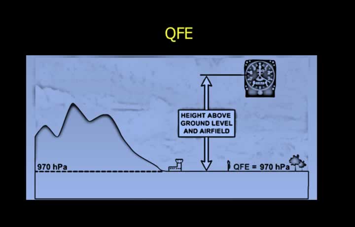
- QFE is the observed pressure reduced to the Aerodrome Reference Point (ARP) using the ISA lapse rate.
- It represents the atmospheric pressure at the airfield.
When QFE is set on the altimeter:
- On the ground, the altimeter reads approximately zero.
- During flight, the altimeter indicates Height Above Ground Level (AGL).
QNH
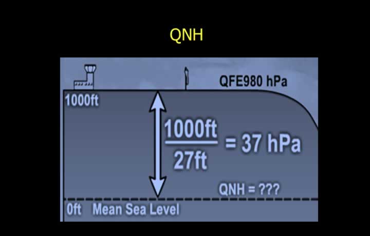
- QNH is the observed pressure reduced to Mean Sea Level using the ISA lapse rate.
- The same lapse rate is used for calibrating aircraft altimeters.
When QNH is set:
- On the ground, the altimeter indicates the elevation of the airfield.
- During flight, it indicates Altitude Above Mean Sea Level (AMSL).
QNH can be calculated from QFE.
- For airfields below 5000 ft AMSL, add approximately 1 hPa for every 27 ft of elevation.
Standard Pressure Setting (SPS)
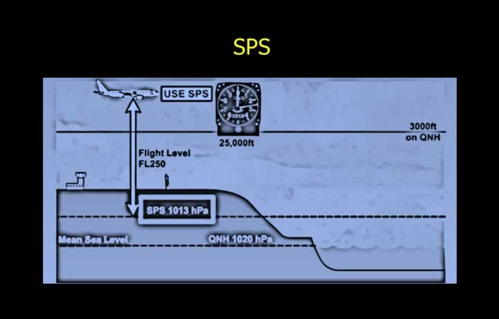
- Standard Pressure Setting is the ISA pressure at Mean Sea Level.
- Standard value: 1013 hPa (1013.25 hPa).
- Pressure altitude is obtained when the altimeter subscale is set to SPS.
Flight Level
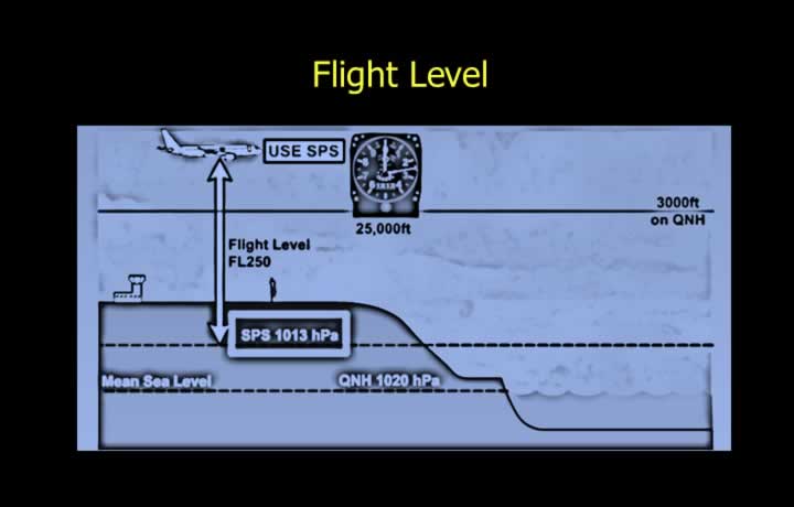
- Flight Levels (FL) are constant pressure surfaces used to maintain vertical separation between aircraft.
- Adjacent flight levels are separated by 500 ft.
- FL050 represents a pressure altitude of 5,000 ft.
QNE (Standard Pressure Setting)
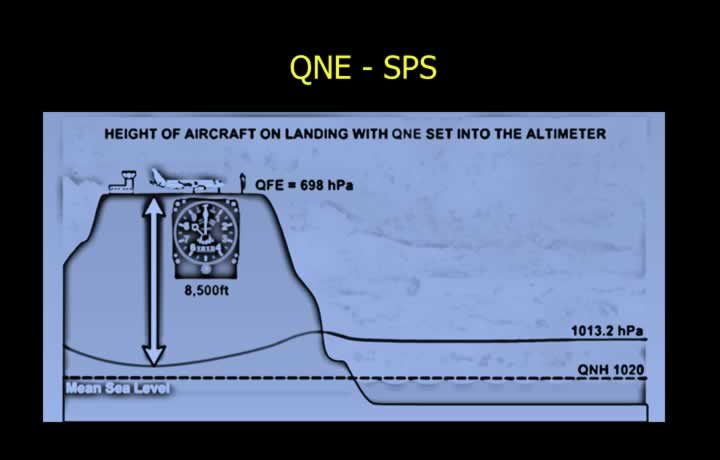
- QNE is the altitude indicated at an airfield when the altimeter is set to the Standard Pressure Setting (1013 hPa).
- It is mainly used at high-altitude airfields where QFE cannot be set because the required pressure is outside the altimeter subscale range.
QFF
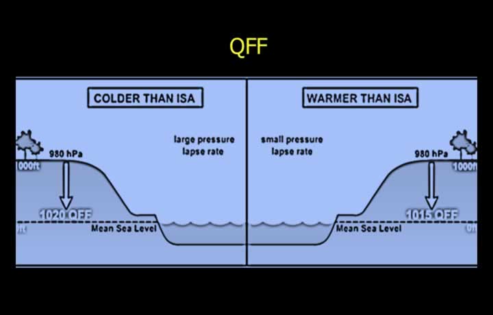
- QFF is the observed pressure reduced to Mean Sea Level using the actual atmospheric conditions.
- QFF is used for preparing pressure charts.
- It is not suitable for aircraft altimeters because altimeters are calibrated using ISA conditions.
Temperature affects the pressure lapse rate and therefore QFF:
- Warm temperatures produce a lower lapse rate, resulting in a higher QFF.
- Cold temperatures produce a higher lapse rate, resulting in a lower QFF.
Comparison Between QFF and QNH
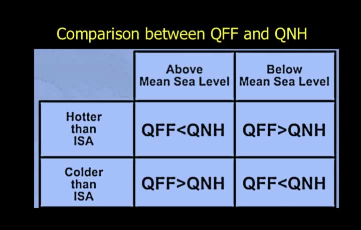
QFF and QNH differ whenever the actual temperature differs from ISA temperature.
For airfields above Mean Sea Level:
- In warmer-than-ISA conditions:
- QFF < QNH
- The pressure decreases more slowly with height because the air is less dense.
- In colder-than-ISA conditions:
- QFF > QNH
- The pressure decreases more rapidly with height because the air is denser.
For airfields below Mean Sea Level, these relationships are reversed.
Effect of Temperature and Pressure Variation during flight on a Pressure Altimeter
Flight from High Pressure to Low Pressure
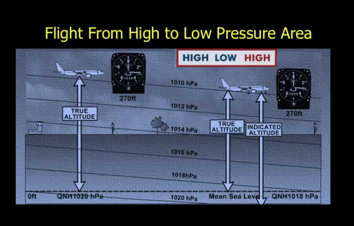
- When flying from a high-pressure area to a low-pressure area, the altimeter indicates a higher altitude than the aircraft’s true altitude.
- True altitude is lower than indicated altitude.
- The altimeter over-reads, reducing terrain clearance.
- This situation is potentially dangerous.
Flight from Low Pressure to High Pressure
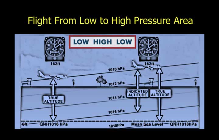
- When flying from a low-pressure area to a high-pressure area, the altimeter indicates a lower altitude than the true altitude.
- True altitude is higher than indicated altitude.
- The altimeter under-reads, increasing terrain clearance.
- This is generally less hazardous from a terrain clearance perspective.
Temperature Error – Cold Air
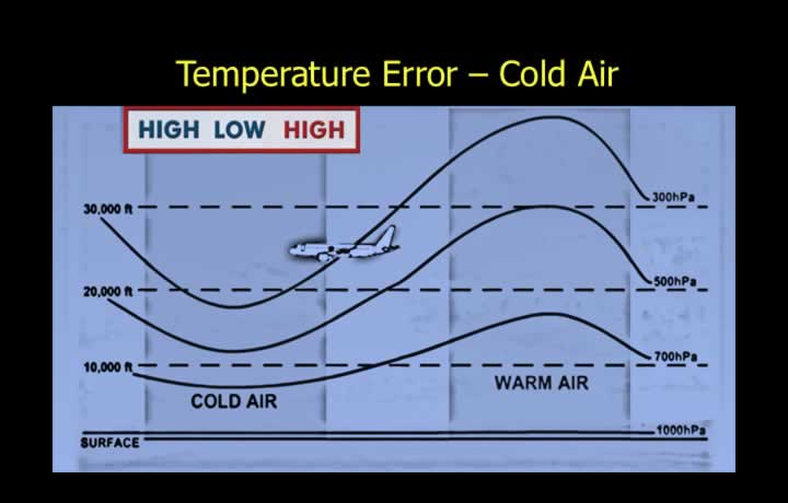
Consider a flight between two locations having the same Mean Sea Level pressure.
- Cold air has a higher pressure lapse rate.
- At a given altitude, the observed pressure is lower.
- The indicated altitude becomes higher than the true altitude.
- The altimeter over-reads when flying into colder air.
Temperature Error – Warm Air
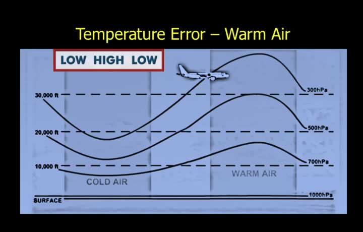
Consider a flight between two locations having the same Mean Sea Level pressure.
- Warm air has a lower pressure lapse rate.
- At a given altitude, the observed pressure is higher.
- The indicated altitude becomes lower than the true altitude.
- The altimeter under-reads when flying into warmer air.
Regional QNH
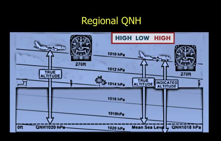
- Regional QNH is the lowest forecast QNH within an Altimeter Setting Region.
- It is issued every hour.
- Used while flying close to the ground.
- Ensures adequate minimum terrain clearance.