
Altimetry – Terminologies
The main terminologies used in altimetry are indicated altitude, pressure altitude, true altitude, absolute altitude, density altitude, QNH, QFE, and QNE. These terms define different altitude references and barometric pressure settings used during flight.
Height Above Mean Sea Level (AMSL)
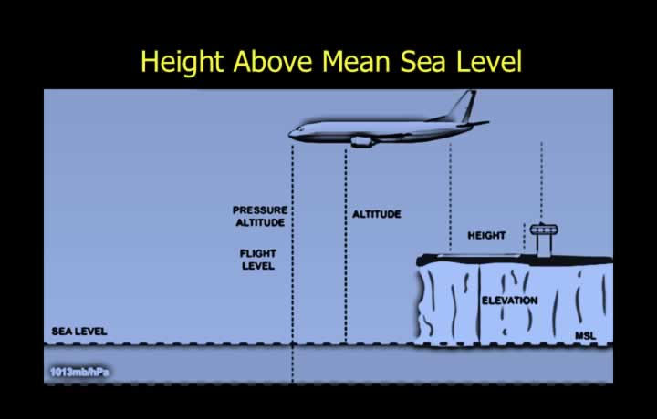
- Mean Sea Level (MSL) is the average sea level determined by averaging tidal variations.
- MSL is the standard reference (datum) for measuring altitude and elevation.
- Altitude is the vertical distance of an aircraft or other object above Mean Sea Level.
- Elevation is the vertical distance of a fixed point on the Earth’s surface above Mean Sea Level.
- Both altitude and elevation are expressed as Above Mean Sea Level (AMSL).
Height Above Ground Level (AGL)
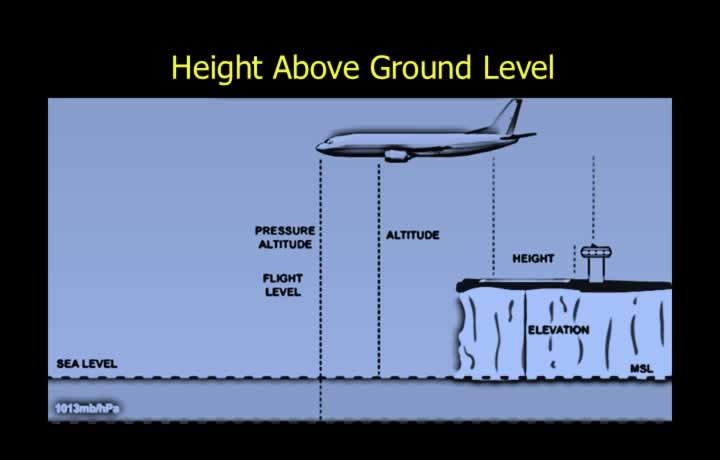
- The Airfield Reference Point (ARP) is the reference point for an airfield.
- Height is the vertical distance above a specified datum.
- The ARP serves as the datum for measuring height above an airfield.
- Height above an airfield is expressed as Above Ground Level (AGL).
Pressure Altitude and Flight Levels
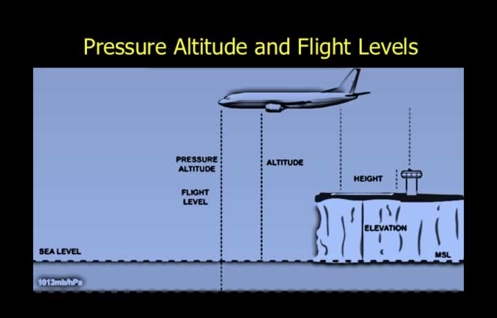
- Standard Pressure Setting (SPS) is the International Standard Atmosphere (ISA) pressure at Mean Sea Level.
- The standard pressure value is 1013.25 hPa.
- Pressure Altitude is the altitude indicated when the altimeter sub-scale is set to 1013.25 hPa.
- Flight Levels (FL) are constant pressure surfaces.
- Adjacent Flight Levels are normally separated vertically by 500 ft.
- For example, FL050 represents a pressure altitude of 5,000 ft.
Use of Datum Setting for Pressure Altimeter
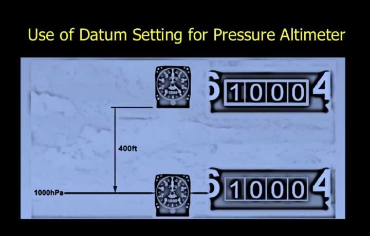
- The altitude indicated by the altimeter is referenced to the selected datum pressure.
- The instrument converts pressure differences into altitude based on ISA conditions.
- For example, when a datum pressure of 1000 hPa is selected:
- The altimeter compares the prevailing pressure with the selected datum pressure.
- The pressure difference is converted into altitude using ISA calibration.
- The corresponding altitude is displayed on the instrument dial.
QFE – QNH – QFF – SPS – QNE
QFE
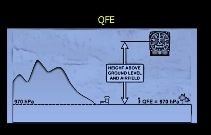
- QFE is the observed atmospheric pressure reduced to the Airfield Reference Point (ARP) using the ISA lapse rate.
- It represents the atmospheric pressure at the airfield.
- When QFE is set on the altimeter:
- On the ground, the altimeter reads approximately 0 ft.
- In flight, the altimeter indicates Height Above Ground Level (AGL).
QNH
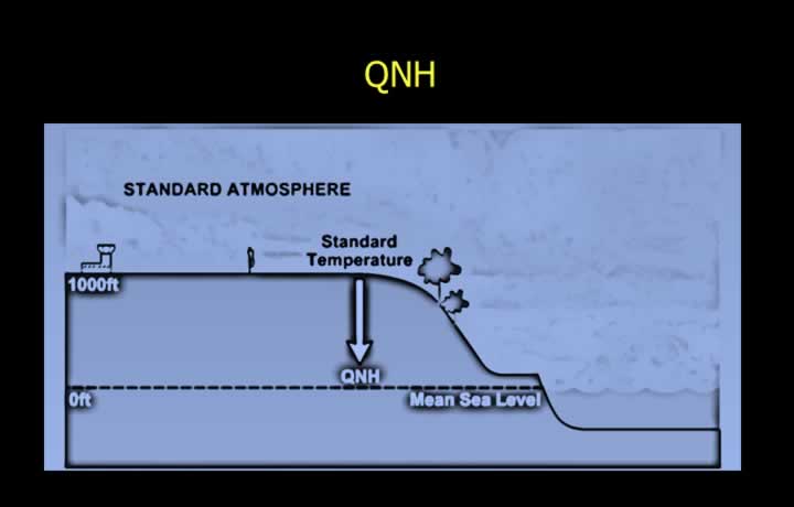
- QNH is the observed atmospheric pressure reduced to Mean Sea Level using the ISA lapse rate.
- The same lapse rate is used to calibrate pressure altimeters.
- When QNH is selected:
- On the ground, the altimeter indicates the airfield elevation.
- In flight, the altimeter indicates altitude above Mean Sea Level.
Standard Pressure Setting (SPS)
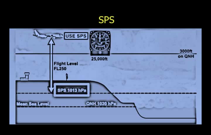
- SPS is the ISA pressure at Mean Sea Level.
- The standard value is 1013 hPa (1013.25 hPa).
- When SPS is selected, the altimeter indicates Pressure Altitude.
Flight Level – Transition Altitude – Transition Level – Transition Layer
Flight Level
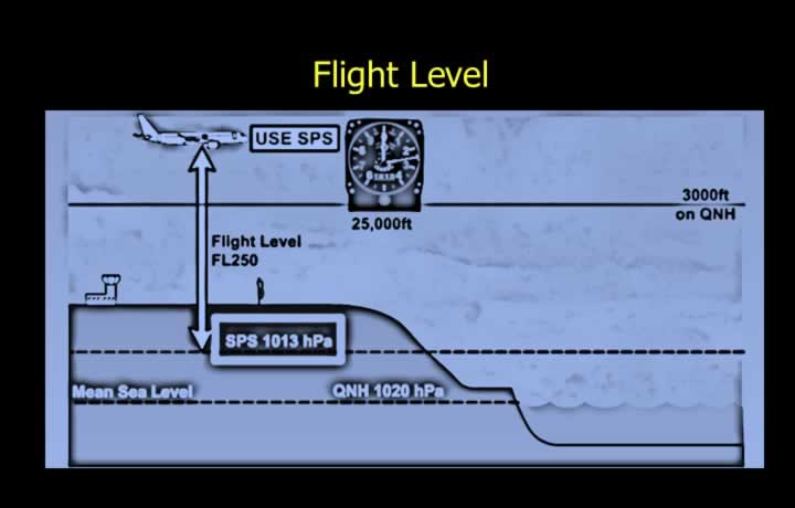
- Flight Levels are surfaces of constant atmospheric pressure.
- Standard vertical separation between Flight Levels is 500 ft.
- FL050 corresponds to a Pressure Altitude of 5,000 ft.
QNE (Standard Pressure Setting)
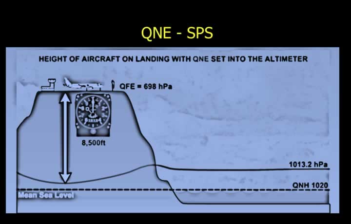
- QNE is the altitude indicated on the ground when the altimeter is set to the Standard Pressure Setting (1013 hPa).
- It is mainly used at high-elevation airfields where QFE cannot be selected.
- This occurs because the required QFE may fall outside the adjustment range of the altimeter sub-scale.
Transition Altitude (Climb)
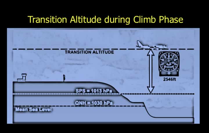
- The Transition Altitude is the altitude during climb at which the altimeter is reset to the Standard Pressure Setting (1013 hPa).
- It varies between airfields.
- It normally remains constant for a particular airfield.
Altimeter Indications During Climb at Transition Altitude
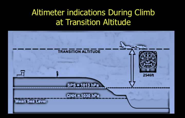
- If changing from a high QNH (1030 hPa) to 1013 hPa, the indicated altitude decreases suddenly.
- If changing from a low QNH (1000 hPa) to 1013 hPa, the indicated altitude increases suddenly.
Transition Level (Descent)
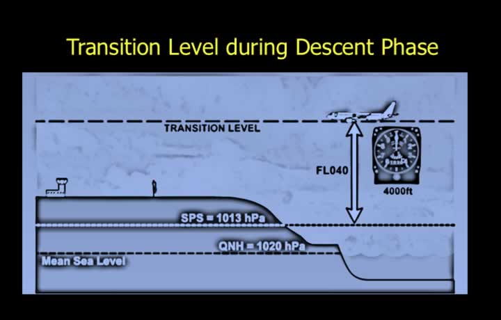
- The Transition Level is the altitude during descent at which the altimeter is reset from Standard Pressure to the local QNH.
- It varies from one airfield to another.
- Unlike Transition Altitude, it can vary from day to day depending on atmospheric pressure.
Altimeter Indications During Descent at Transition Level
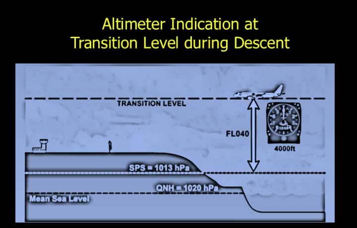
- If changing from 1013 hPa to a high QNH (1020 hPa), the indicated altitude increases.
- If changing from 1013 hPa to a low QNH (1000 hPa), the indicated altitude decreases.
Transition Layer
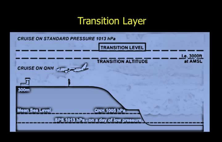
- The Transition Layer is the airspace between the Transition Altitude and the Transition Level.
Calculation of QNH from QFE
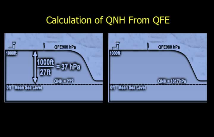
- For airfields below 5,000 ft:
- Add 1 hPa for every 27 ft of elevation.
- For airfields above 5,000 ft:
- Add 1 hPa for every 25 ft of elevation.
Effect of Altitude on Density and Aircraft Performance
Density Altitude
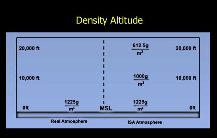
- Density Altitude is the altitude in the ISA at which the prevailing air density exists.
- It is similar to Pressure Altitude, which is based on atmospheric pressure.
- Under ISA conditions, Pressure Altitude and Density Altitude are identical.
- Density Altitude is an important factor in aircraft performance calculations.
- Lower Density Altitude provides better aircraft performance.
- Higher Density Altitude results in poorer aircraft performance.
Air Density in High, Hot, and Humid Conditions
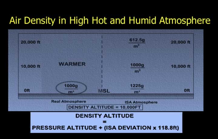
- Air density decreases under the following conditions:
- High altitude.
- Temperature above ISA.
- High humidity.
- Lower air density results in a higher Density Altitude.
Calculation of Density Altitude
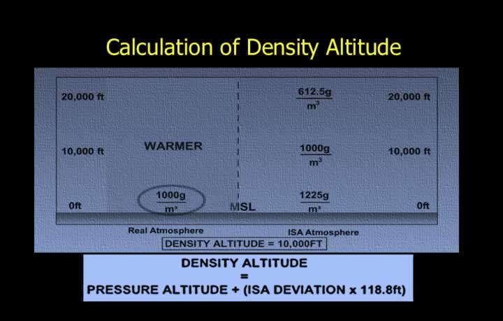
- Higher Density Altitude reduces aircraft performance.
- For example, the take-off distance required increases.
- Performance calculations should always be verified before take-off.
- Density Altitude can be determined using the ISA Deviation.
- Density Altitude = Pressure Altitude + (120 × ISA Deviation)